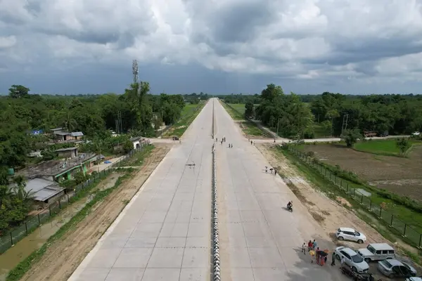
Shillong-Silchar Highway is set to redefine connectivity and strategic mobility in North-East India. The Government of India has greenlit a landmark infrastructure project — the construction of a 166.8 km four-lane highway along National Highway 6 (NH-6), stretching from Mawlyngkhung near Shillong in Meghalaya to Panchgram near Silchar in Assam.
As the region’s first high-speed corridor, the Shillong-Silchar Highway is more than just a road — it is a transformative link that opens up a vital alternative maritime route to Kolkata via Myanmar, completely bypassing Bangladesh. This bold move not only boosts regional trade and defense logistics but also strengthens India’s Act East Policy.
Strategic Importance of the Shillong-Silchar Highway
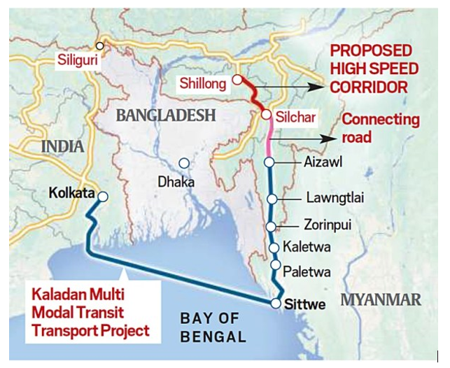
The need for this corridor stems from geopolitical and logistical constraints associated with the Siliguri Corridor (also known as the Chicken’s Neck), which is currently the only land access route connecting the North-East with the rest of India. The Siliguri route is narrow, congested, and vulnerable to disruption. While Bangladesh has been providing access to the Bay of Bengal for Indian cargo, recent remarks and policy signals from Dhaka, including a statement by Bangladesh’s interim government chief adviser Muhammad Yunus referring to North-East India as “landlocked,” highlighted the vulnerability of depending on a foreign nation for maritime access.
To counter this, India has initiated steps to operationalize an alternative route via the Kaladan Multi-Modal Transit Transport Project in Myanmar, which will connect the Kolkata seaport to the North-East through a combination of sea, inland waterway, and road transport. The proposed Shillong–Silchar highway will become a crucial land component of this multi-modal route, enhancing connectivity to Mizoram, Manipur, Tripura, and the Barak Valley in Assam.
Project Overview of the Shillong-Silchar Highway
The Shillong–Silchar highway, approved on April 30, 2025, by the Union Cabinet at a total cost of ₹22,864 crore, will traverse 144.8 km through Meghalaya and 22 km through Assam. It will be implemented by the National Highways & Infrastructure Development Corporation Limited (NHIDCL) under the Ministry of Road Transport and Highways (MoRTH). The completion deadline for the project is 2030.
The project aims to significantly reduce travel time from Shillong to Silchar – from the current 8.5 hours to just 5 hours – and provide all-weather connectivity through difficult hilly terrain. It will include 19 major bridges, 153 minor bridges, 326 culverts, 22 underpasses, 26 overpasses, eight limited-height subways, and 34 viaducts.
Integration with Kaladan Project
The Kaladan Multi-Modal Transit Transport Project is being developed with funding from the Ministry of External Affairs and is key to India’s Act East Policy. It connects the Sittwe port in Rakhine State (Myanmar) with Paletwa via the Kaladan River and further extends to Zorinpui in Mizoram through a road link. The Shillong–Silchar highway will extend this link by road to other parts of the North-East, forming a seamless multi-modal corridor.
Through this link, cargo can move from Vizag or Kolkata by sea to Sittwe, then inland to Zorinpui, and onward by road to Mizoram and through Silchar to the rest of the North-East. This effectively eliminates dependency on Bangladesh for trade access to the ocean, thereby enhancing India’s strategic autonomy and regional resilience.
Engineering and Technological Features
The terrain between Shillong and Silchar is mountainous and prone to landslides. To ensure stability and safety, advanced engineering and slope stabilization techniques will be deployed. The National Institute of Rock Mechanics has been engaged to study rock behavior, and the following protective measures are being planned:
- Rock Anchors: To stabilize loose rock surfaces.
- High-Strength Wire Mesh Panels: To prevent falling debris.
- Protection Walls: For structural safety along vulnerable zones.
Advanced topographical surveys using LiDAR (Light Detection and Ranging) technology have already been conducted. Monitoring instruments include:
- Piezometers: For monitoring pore water pressure.
- Rain Gauges: For measuring rainfall intensity.
- Settlement Gauges: For tracking ground subsidence.
- Inclinometers: For detecting ground movement and slope instability.
- Geophones: For vibration monitoring and seismic activity analysis.
These tools will ensure that construction is resilient and disaster-preventive, with real-time monitoring for landslide-prone areas.
Implementation Model
The project will be executed under the Hybrid Annuity Model (HAM), a Public-Private Partnership (PPP) structure wherein the government provides 40% of the project cost during the construction phase, and the remaining 60% is paid as annuities over the operational period, along with operation and maintenance payments.
Significance
- Strategic Importance: Reduces dependency on Bangladesh and the vulnerable Siliguri Corridor.
- Economic Boost: Enhances trade, transportation, and employment in the North-East.
- Geopolitical Leverage: Counters Chinese influence in Bangladesh and reinforces India’s presence in Myanmar.
- Regional Integration: Promotes inter-state connectivity and supports India’s Act East Policy.
- Disaster Resilience: Incorporates modern technology to withstand geohazards in the hilly terrain.
Conclusion
The Shillong–Silchar highway is more than just an infrastructure project; it is a strategic lifeline for the North-East. Integrated with the Kaladan project, it will provide maritime access independent of Bangladesh, enhance economic opportunities in the region, and serve as a vital component of India’s larger regional and strategic ambitions.
Read: Irrigation Crisis of India
Download App: